Satellite
Satellite
From Wikipedia, the free encyclopedia
This article is about artificial satellites. For natural satellites, also known as moons, see Natural satellite. For other uses, see Satellite (disambiguation).
| Part of a series on |
| Spaceflight |
|---|
 |
| History |
| Applications |
| Spacecraft |
| Launch |
| Destinations |
| Space agencies |
| Private spaceflight |


In the context of spaceflight, a satellite is an artificial object which has been intentionally placed into orbit. Such objects are sometimes called artificial satellites to distinguish them from natural satellites such as Earth's Moon.
The world's first artificial satellite, the Sputnik 1, was launched by the Soviet Union in 1957. Since then, thousands of satellites have been launched into orbit around the Earth. Some satellites, notably space stations, have been launched in parts and assembled in orbit. Artificial satellites originate from more than 40 countries and have used the satellite launching capabilities of ten nations. A few hundred satellites are currently operational, whereas thousands of unused satellites and satellite fragments orbit the Earth as space debris. A few space probes have been placed into orbit around other bodies and become artificial satellites to the Moon, Mercury,Venus, Mars, Jupiter, Saturn, Vesta, Eros, Ceres,[1] and the Sun.
Satellites are used for a large number of purposes. Common types include military and civilian Earth observation satellites,communications satellites, navigation satellites, weather satellites, and research satellites. Space stations and human spacecraft in orbit are also satellites. Satellite orbits vary greatly, depending on the purpose of the satellite, and are classified in a number of ways. Well-known (overlapping) classes include low Earth orbit, polar orbit, and geostationary orbit.
About 6,600 satellites have been launched. The latest estimates are that 3,600 remain in orbit.[2] Of those, about 1,000 are operational;[3][4] the rest have lived out their useful lives and are part of the space debris. Approximately 500 operational satellites are in low-Earth orbit, 50 are in medium-Earth orbit (at 20,000 km), the rest are in geostationary orbit (at 36,000 km).[5]
Satellites are propelled by rockets to their orbits. Usually the launch vehicle itself is a rocket lifting off from a launch pad on land. In a minority of cases satellites are launched at sea (from a submarine or a mobile maritime platform) or aboard a plane (see air launch to orbit).
Satellites are usually semi-independent computer-controlled systems. Satellite subsystems attend many tasks, such as power generation, thermal control, telemetry, attitude control and orbit control.
Contents
[hide]History[edit]
Early conceptions[edit]
"Newton's cannonball", presented as a "thought experiment" in A Treatise of the System of the World, by Isaac Newton was the first published mathematical study of the possibility of an artificial satellite.
The first fictional depiction of a satellite being launched into orbit is a short story by Edward Everett Hale, The Brick Moon. The story is serialized in The Atlantic Monthly, starting in 1869.[6][7] The idea surfaces again in Jules Verne's The Begum's Fortune (1879).

In 1903, Konstantin Tsiolkovsky (1857–1935) published Exploring Space Using Jet Propulsion Devices (in Russian: Исследование мировых пространств реактивными приборами), which is the first academic treatise on the use of rocketry to launch spacecraft. He calculated the orbital speed required for a minimal orbit around the Earth at 8 km/s, and that a multi-stage rocket fuelled by liquidpropellants could be used to achieve this. He proposed the use of liquid hydrogen and liquid oxygen, though other combinations can be used.
In 1928, Slovenian Herman Potočnik (1892–1929) published his sole book, The Problem of Space Travel — The Rocket Motor (German:Das Problem der Befahrung des Weltraums — der Raketen-Motor), a plan for a breakthrough into space and a permanent human presence there. He conceived of a space station in detail and calculated its geostationary orbit. He described the use of orbiting spacecraft for detailed peaceful and military observation of the ground and described how the special conditions of space could be useful for scientific experiments. The book described geostationary satellites (first put forward by Tsiolkovsky) and discussed communication between them and the ground using radio, but fell short of the idea of using satellites for mass broadcasting and as telecommunications relays.
In a 1945 Wireless World article, the English science fiction writer Arthur C. Clarke (1917–2008) described in detail the possible use of communications satellites for mass communications.[8] Clarke examined the logistics of satellite launch, possible orbits and other aspects of the creation of a network of world-circling satellites, pointing to the benefits of high-speed global communications. He also suggested that three geostationary satellites would provide coverage over the entire planet.
The US military studied the idea of what was referred to as the earth satellite vehicle when Secretary of Defense James Forrestal made a public announcement on December 29, 1948, that his office was coordinating that project between the various services.[9]
Artificial satellites[edit]

The first artificial satellite was Sputnik 1, launched by the Soviet Union on October 4, 1957, and initiating the Soviet Sputnik program, with Sergei Korolev as chief designer (there is a crater on the lunar far side which bears his name). This in turn triggered the Space Race between the Soviet Union and the United States.
Sputnik 1 helped to identify the density of high atmospheric layers through measurement of its orbital change and provided data on radio-signal distribution in the ionosphere. The unanticipated announcement of Sputnik 1's success precipitated the Sputnik crisis in the United States and ignited the so-called Space Race within the Cold War.
Sputnik 2 was launched on November 3, 1957 and carried the first living passenger into orbit, a dog named Laika.[10]
In May, 1946, Project RAND had released the Preliminary Design of an Experimental World-Circling Spaceship, which stated, "A satellite vehicle with appropriate instrumentation can be expected to be one of the most potent scientific tools of the Twentieth Century."[11] The United States had been considering launching orbital satellites since 1945 under the Bureau of Aeronautics of theUnited States Navy. The United States Air Force's Project RAND eventually released the above report, but did not believe that the satellite was a potential military weapon; rather, they considered it to be a tool for science, politics, and propaganda. In 1954, the Secretary of Defense stated, "I know of no American satellite program."[12] In February 1954 Project RAND released "Scientific Uses for a Satellite Vehicle," written by R.R. Carhart.[13] This expanded on potential scientific uses for satellite vehicles and was followed in June 1955 with "The Scientific Use of an Artificial Satellite," by H.K. Kallmann and W.W. Kellogg.[14]
In the context of activities planned for the International Geophysical Year (1957–58), the White House announced on July 29, 1955 that the U.S. intended to launch satellites by the spring of 1958. This became known as Project Vanguard. On July 31, the Soviets announced that they intended to launch a satellite by the fall of 1957.
Following pressure by the American Rocket Society, the National Science Foundation, and the International Geophysical Year, military interest picked up and in early 1955 the Army and Navy were working on Project Orbiter, two competing programs: the army's which involved using a Jupiter C rocket, and the civilian/Navy Vanguard Rocket, to launch a satellite. At first, they failed: initial preference was given to the Vanguard program, whose first attempt at orbiting a satellite resulted in the explosion of the launch vehicle on national television. But finally, three months after Sputnik 2, the project succeeded; Explorer 1 became the United States' first artificial satellite on January 31, 1958.[15]
In June 1961, three-and-a-half years after the launch of Sputnik 1, the Air Force used resources of the United States Space Surveillance Network to catalog 115 Earth-orbiting satellites.[16]
Early satellites were constructed as "one-off" designs. With growth in geosynchronous (GEO) satellite communication, multiple satellites began to be built on single model platforms called satellite buses. The first standardized satellite bus design was the HS-333 GEO commsat, launched in 1972.
The largest artificial satellite currently orbiting the Earth is the International Space Station.

Space Surveillance Network[edit]
Main article: United States Space Surveillance Network
The United States Space Surveillance Network (SSN), a division of The United States Strategic Command, has been tracking objects in Earth's orbit since 1957 when the Soviets opened the space age with the launch of Sputnik I. Since then, the SSN has tracked more than 26,000 objects. The SSN currently tracks more than 8,000 man-made orbiting objects. The rest have re-entered Earth's atmosphere and disintegrated, or survived re-entry and impacted the Earth. The SSN tracks objects that are 10 centimeters in diameter or larger; those now orbiting Earth range from satellites weighing several tons to pieces of spent rocket bodies weighing only 10 pounds. About seven percent are operational satellites (i.e. ~560 satellites), the rest are space debris.[17] The United States Strategic Command is primarily interested in the active satellites, but also tracks space debris which upon reentry might otherwise be mistaken for incoming missiles.
A search of the NSSDC Master Catalog at the end of October 2010 listed 6,578 satellites launched into orbit since 1957, the latest beingChang'e 2, on 1 October 2010.[18]
Non-military satellite services[edit]
There are three basic categories of non-military satellite services:[19]
Fixed satellite services[edit]
Fixed satellite services handle hundreds of billions of voice, data, and video transmission tasks across all countries and continents between certain points on the Earth's surface.
Mobile satellite systems[edit]
Mobile satellite systems help connect remote regions, vehicles, ships, people and aircraft to other parts of the world and/or other mobile or stationary communications units, in addition to serving as navigation systems.
Scientific research satellites (commercial and noncommercial)[edit]
Scientific research satellites provide meteorological information, land survey data (e.g. remote sensing), Amateur (HAM) Radio, and other different scientific research applications such as earth science, marine science, and atmospheric research.
Types[edit]
- Astronomical satellites are satellites used for observation of distant planets, galaxies, and other outer space objects.
- Biosatellites are satellites designed to carry living organisms, generally for scientific experimentation.
- Communications satellites are satellites stationed in space for the purpose of telecommunications. Modern communications satellites typically use geosynchronous orbits,Molniya orbits or Low Earth orbits.
- Earth observation satellites are satellites intended for non-military uses such as environmental monitoring, meteorology, map making etc. (See especially Earth Observing System.)
- Navigational satellites are satellites which use radio time signals transmitted to enable mobile receivers on the ground to determine their exact location. The relatively clear line of sight between the satellites and receivers on the ground, combined with ever-improving electronics, allows satellite navigation systems to measure location to accuracies on the order of a few meters in real time.
- "Killer Satellites" are satellites that are designed to destroy enemy warheads, satellites, and other space assets.
- Manned spacecraft (spaceships) are large satellites able to put humans into (and beyond) an orbit, and return them to Earth. Spacecraft including spaceplanes of reusable systems have major propulsion or landing facilities. They can be used as transport to and from the orbital stations.
- Miniaturized satellites are satellites of unusually low masses and small sizes.[20] New classifications are used to categorize these satellites: minisatellite (500–100 kg),microsatellite (below 100 kg), nanosatellite (below 10 kg).[citation needed]
- Reconnaissance satellites are Earth observation satellite or communications satellite deployed for military or intelligence applications. Very little is known about the full power of these satellites, as governments who operate them usually keep information pertaining to their reconnaissance satellites classified.
- Recovery satellites are satellites that provide a recovery of reconnaissance, biological, space-production and other payloads from orbit to Earth.

- Space stations are man-made orbital structures that are designed for human beings to live on in outer space. A space station is distinguished from other manned spacecraft by its lack of major propulsion or landing facilities. Space stations are designed for medium-term living in orbit, for periods of weeks, months, or even years.
- Tether satellites are satellites which are connected to another satellite by a thin cable called a tether.
- Weather satellites are primarily used to monitor Earth's weather and climate.[21]
Orbit types[edit]
Main article: List of orbits

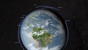
The first satellite, Sputnik 1, was put into orbit around Earth and was therefore in geocentric orbit. By far this is the most common type of orbit with approximately 2,465[citation needed] artificial satellites orbiting the Earth. Geocentric orbits may be further classified by their altitude, inclination and eccentricity.
The commonly used altitude classifications of geocentric orbit are Low Earth orbit (LEO), Medium Earth orbit (MEO) and High Earth orbit (HEO). Low Earth orbit is any orbit below 2,000 km. Medium Earth orbit is any orbit between 2,000 km-35,786 km. High Earth orbit is any orbit higher than 35,786 km.
Centric classifications[edit]
- Geocentric orbit: An orbit around the planet Earth, such as the Moon or artificial satellites. Currently there are approximately 2,465[citation needed] artificial satellites orbiting the Earth.
- Heliocentric orbit: An orbit around the Sun. In our Solar System, all planets, comets, and asteroids are in such orbits, as are many artificial satellites and pieces of space debris. Moons by contrast are not in a heliocentric orbit but rather orbit their parent planet.
- Areocentric orbit: An orbit around the planet Mars, such as by moons or artificial satellites.
The general structure of a satellite is that it is connected to the earth stations that are present on the ground and connected through terrestrial links.
Altitude classifications[edit]
- Low Earth orbit (LEO): Geocentric orbits ranging in altitude from 0–2000 km (0–1240 miles)
- Medium Earth orbit (MEO): Geocentric orbits ranging in altitude from 2,000 km (1,200 mi)-35,786 km (22,236 mi). Also known as an intermediate circular orbit.
- Geosynchronous Orbit (GEO): Geocentric circular orbit with an altitude of 35,786 kilometres (22,236 mi). The period of the orbit equals one sidereal day, coinciding with the rotation period of the Earth. The speed is approximately 3,000 metres per second (9,800 ft/s).
- High Earth orbit (HEO): Geocentric orbits above the altitude of geosynchronous orbit 35,786 km (22,236 mi).

Inclination classifications[edit]
- Inclined orbit: An orbit whose inclination in reference to the equatorial plane is not zero degrees.
- Polar orbit: An orbit that passes above or nearly above both poles of the planet on each revolution. Therefore, it has an inclination of (or very close to) 90 degrees.
- Polar sun synchronous orbit: A nearly polar orbit that passes the equator at the same local time on every pass. Useful for image taking satellites because shadows will be nearly the same on every pass.
Eccentricity classifications[edit]
- Circular orbit: An orbit that has an eccentricity of 0 and whose path traces a circle.
- Hohmann transfer orbit: An orbit that moves a spacecraft from one approximately circular orbit, usually the orbit of a planet, to another, using two engine impulses. Theperihelion of the transfer orbit is at the same distance from the Sun as the radius of one planet's orbit, and the aphelion is at the other. The two rocket burns change the spacecraft's path from one circular orbit to the transfer orbit, and later to the other circular orbit. This maneuver was named after Walter Hohmann.
- Elliptic orbit: An orbit with an eccentricity greater than 0 and less than 1 whose orbit traces the path of an ellipse.
- Geosynchronous transfer orbit: An elliptic orbit where the perigee is at the altitude of a Low Earth orbit (LEO) and the apogee at the altitude of a geosynchronous orbit.
- Geostationary transfer orbit: An elliptic orbit where the perigee is at the altitude of a Low Earth orbit (LEO) and the apogee at the altitude of a geostationary orbit.
- Molniya orbit: A highly elliptic orbit with inclination of 63.4° and orbital period of half of a sidereal day (roughly 12 hours). Such a satellite spends most of its time over two designated areas of the planet (specifically Russia and the United States).
- Tundra orbit: A highly elliptic orbit with inclination of 63.4° and orbital period of one sidereal day (roughly 24 hours). Such a satellite spends most of its time over a single designated area of the planet.


تعليقات
إرسال تعليق